The longest train journey in the EU

Anyone who has been following my work for a while knows I have long had a rather abstract discussion about the definition of the World's Longest Train Journey. I started calculating this back in 2021, after an incorrect map on Reddit went viral, and have updated my thoughts about it since in this post.
But both the world's longest, and even Europe's (as a continent) longest rail trips go through Russia, and you should not go there, here is an alternative and slightly easier challenge: the longest train journey in the EU. And importantly this is new for 2026.
Definitions of the longest train journey in the EU
There are three definitions that sort of make sense.
The simple and boring one is the most route-km on one single train - that is for the moment 1444.9km on the SJ EuroNight Stockholm - Berlin, although this could be surpassed were night trains to be extended to Riksgränsen in northern Sweden some time again in the future. But anyone who has taken this train in its entirely has set the record - it is not a very challenging one!
The second - that concerns me mostly here - is the two places in Europe that are furthest apart from each other as the crow flies (i.e. Geodesic distance) that can be connected with multiple trains, and - if we want to make a challenge of this - the fastest route between the two.
The third - and it took some persuasion on social media to get me to include it - is what is the greatest route-km between two places in the EU, where no shorter route is available. This one, as I will explain, poses a headache in that it is hard to know what route-km is actually the right outcome, leading me to conclude that geodesic distance is a simpler and more interesting measure.
Geodesic distance - Kemijärvi to Lagos
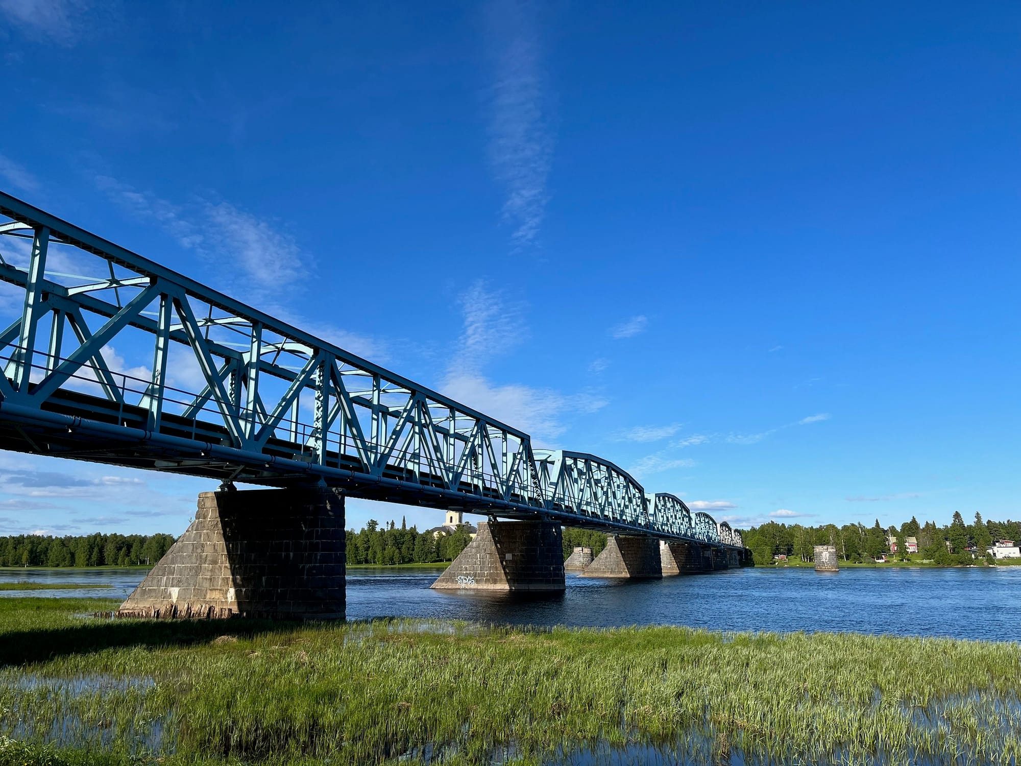
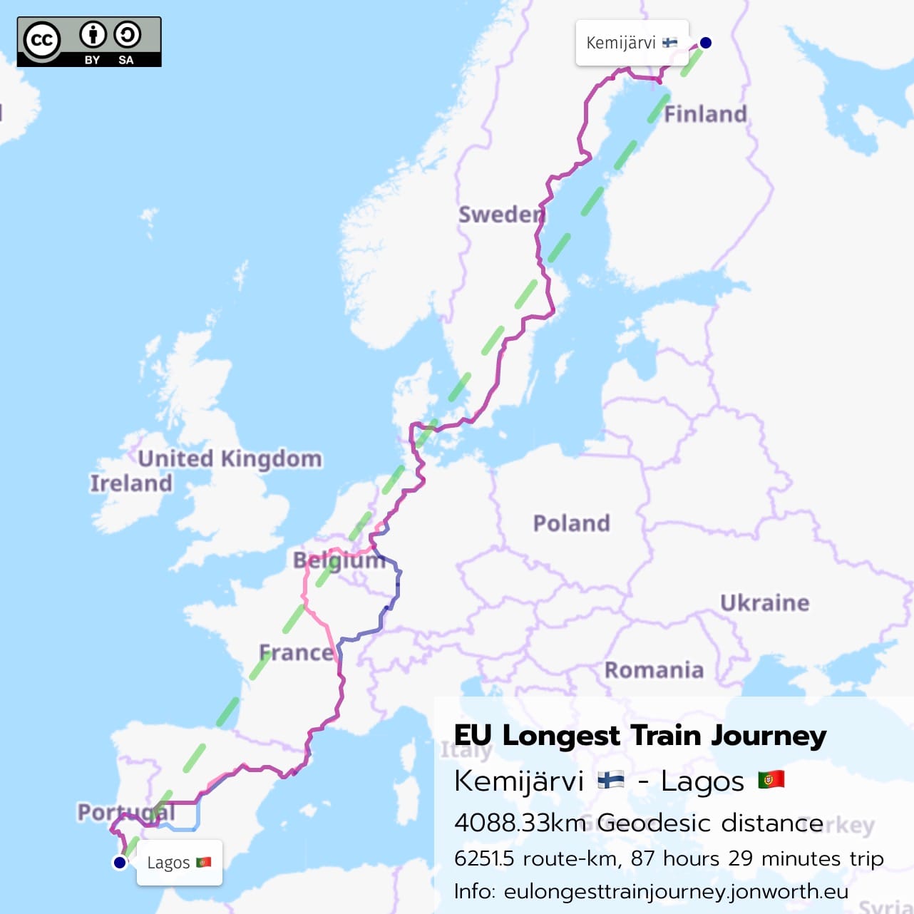
The two points on the railway network that are furthest apart, and can be connected with multiple trains are Kemijärvi, Finland (station geo-coordinates: 66°43′25″N 027°24′14″E or 66.72383, 27.40368) and Lagos, Portugal (station geo-coordinates: 37°6′30.73″N 8°40′18.02″W or 37.1085361111, -8.6716722222)
The geodesic distance between them can be calculated using this tool, and it is 4008.33km.
Note here: if you think some other stations in the EU are further apart, geodesic, please do me a favour of running these through the calculator before you reply to me on social media. Trust me, nothing in Sicily is further from Kemijärvi. Really.
2026: train services from Tornio to Haparanda
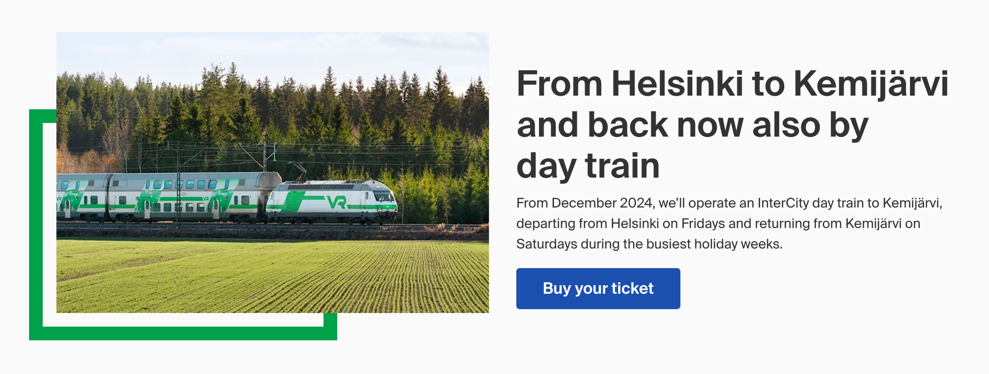
Kemijärvi will become the northern end of the route at some point in 2026 when passenger trains finally run from Finland to Sweden, from Oulu via Kemi and Tornio to Haparanda in Sweden. This means the previous record - 3855km geodesic from Riksgränsen, Sweden, and Lagos, Portugal will be surpassed.
At the moment the precise date for the launch of these services is unknown. This means that neither I, nor anyone else for that matter, has ever done this trip. Passenger trains between Kemi and Haparanda last ran in 1988, and Finland joined the EU in 1995, so it has never before been possible either.
Definitions
I am only considering regular, scheduled railway services for the calculation, and starting and ending points that are publicly accessible passenger stations.
Unlike in the case of the world's longest train journey, here there is no way to extend the route using trams, metros or airport sky trains. This is a heavy rail route from start to end. There is also no need to walk between two stations - the route can be done without that.
The only issue is the definition of a railway station.
The fastest way to complete the route goes through Madrid, and arrives on a standard gauge train at Madrid Puerta de Atocha–Almudena Grandes, and departs on a broad gauge train from Madrid Atocha-Cercanías (OpenRailwayMap). These two stations have separate UIC station codes, although they are in the same building. You can find the full list of UIC codes here.
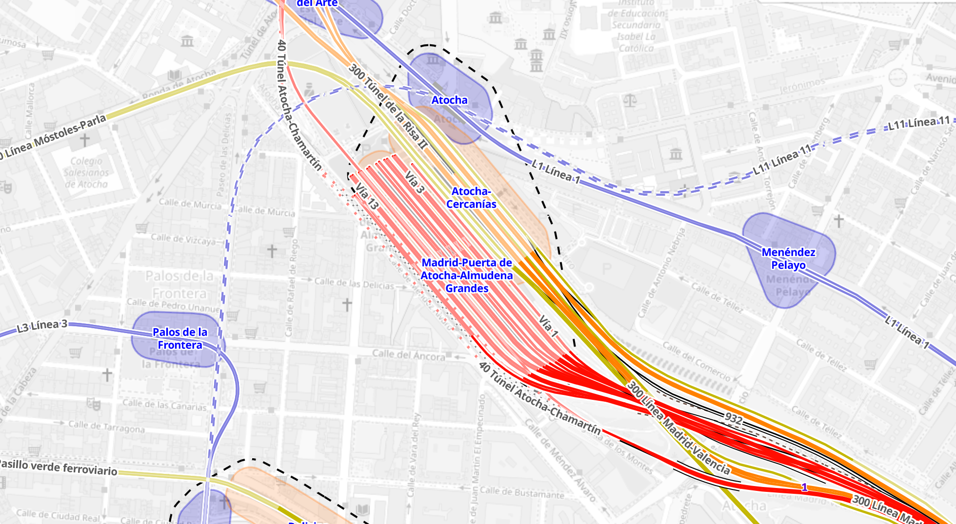
The only semi viable ways around this issue is to change instead in Puertollano (OpenRailwayMap) southbound, or in Chamartín (OpenRailwayMap) and Zaragoza-Delicias (OpenRailwayMap) northbound, adding many hours to the total trip.
Eventually I may submit all of this Guinness World Records for an adjudication of this point, but for the moment my assumption is that walking within the building from Atocha to Atocha-Cercanías is allowed.
Route planning
All of the workings can be found in .ods and .xlsx files on Nextcloud here (including a southbound route via Puertollano and a northbound route via Chamartín) but this is the summary of the quickest route I have found:
| Date | Train | Number | D | D Station | A Station | A | Route-km |
| 04/07/26 | 1 | IC 24 | 07:40 | Kemijärvi | Kemi | 10:38 | 198 |
| 2 | IC 405 | 13:30 | Kemi | Haparanda | 14:30 | 29.9 | |
| 3 | R 7187 | 19:38 | Haparanda | Boden | 21:05 | 159 | |
| 4 | D 93 | 22:18 | Boden | 1019.2 | |||
| 05/07/26 | Stockholm Central | 10:13 | |||||
| 5 | IC 307 | 10:43 | Stockholm Central | Hamburg Hbf | 21:57 | 1157.3 | |
| 6 | ICE 921 | 22:23 | Hamburg Hbf | 471.2 | |||
| 06/07/26 | Köln Hbf | 03:02 | |||||
| 7 | ICE 911 | 05:25 | Köln Hbf | Mannheim Hbf | 06:53 | 240.4 | |
| 8 | ICE 9568 | 07:39 | Mannheim Hbf | Strasbourg | 08:47 | 142.2 | |
| 9 | TGV 9877 | 09:04 | Strasbourg | Lyon Part Dieu | 12:59 | 511.4 | |
| 10 | AVE 9742 | 14:31 | Lyon Part Dieu | Barcelona Sants | 19:23 | 661.5 | |
| 11 | AVE 3310 | 20:00 | Barcelona Sants | Madrid Atocha | 23:44 | 626.5 | |
| 07/07/26 | 12 | A 190 | 08:51 | Madrid Atocha Cercanias | Badajoz | 13:26 | 443.9 |
| 13 | R 482 | 14:09 | Badajoz | Entroncamento | 15:55 | 175.3 | |
| 14 | IC 512 | 15:59 | Entroncamento | Lisboa Oriente | 16:52 | 99.9 | |
| 15 | IC 184 | 17:23 | Lisboa Oriente | Tunes | 19:53 | 270.5 | |
| 16 | R 5914 | 20:07 | Tunes | Lagos | 21:09 | 45.3 |
While the Geodesic distance is 4008.33km, the route-km is 6251.5km. The connection needs 16 trains, and - if everything runs on time - takes 87 hours 29 minutes.
There are doubtless routes with fewer route-km, especially if you were to enter Spain at Hendaye-Irun instead of on a high speed train to Barcelona, but I found no route faster than the one I outline here.
At the time of writing, the final timetable for Kemi - Haparanda is not known, so I have used these provisional times. And using one of the rather uncommon daytime trains from Kemijärvi to Kemi saves time too, so you have to depart Kemijärvi on a summertime Saturday morning.
I have not calculated the individual ticket costs, but the trip would be possible with a 4 day Interrail Global Pass that costs €212 for under 27s or €283 for over 27s, plus some additional reservation costs (especially for the Boden - Stockholm night train). A €400 ticket budget would definitely be sufficient. You could reduce this cost by using non-compulsory reservation trains in France and Spain, but that would add to the total time.
Route alternatives
Were the walk at Atocha not allowed, the solution southbound is to take a high speed train southbound from Atocha to Puertollano and change onto a broad gauge train to Badajoz there (one single station, one single UIC code). But with only two trains a day between Puertollano and Badajoz, this option adds a lot of time - the total is then 102 hours and 29 minutes this way.
Trying to route the other way - starting in Lagos and heading to Kemijärvi - is even more problematic, as speed restrictions on Spanish high speed lines post the Adamuz disaster mean there is no way to get from Madrid to Germany within one day. A route changing in Chamartín and Zaragoza, thereby also avoiding walking between the two halves of Atocha, totals 119 hours 3 minutes.
Future route optimisation
There are numerous headaches with the timetables along the route that could theoretically be alleviated in the future. Removing speed restrictions in Spain post-Adamuz would significantly improve connections in Barcelona, and a further problematic connection in Boden - where the night train arrives at the very same minute as the train to Haparanda departs - could be eliminated in northern Sweden. The provisional timetable of trains from Haparanda to Oulu via Kemi also has some room for improvement, as there is no way based on the times so far available to avoid being stuck in Haparanda for a few hours.
From December 2026 onwards it is possible to imagine a reduction in the trip time down to something closer to 80 hours.
Mapping the route
All of the route variants - southbound walking at Atocha, southbound via Puertollano, and northbound Chamartín - Zaragoza - are mapped on uMap here. And there is a simplified graphic map too:
So all that remains: who is going to be the first person to do it, and will they manage it in 87 hours and 29 minutes?
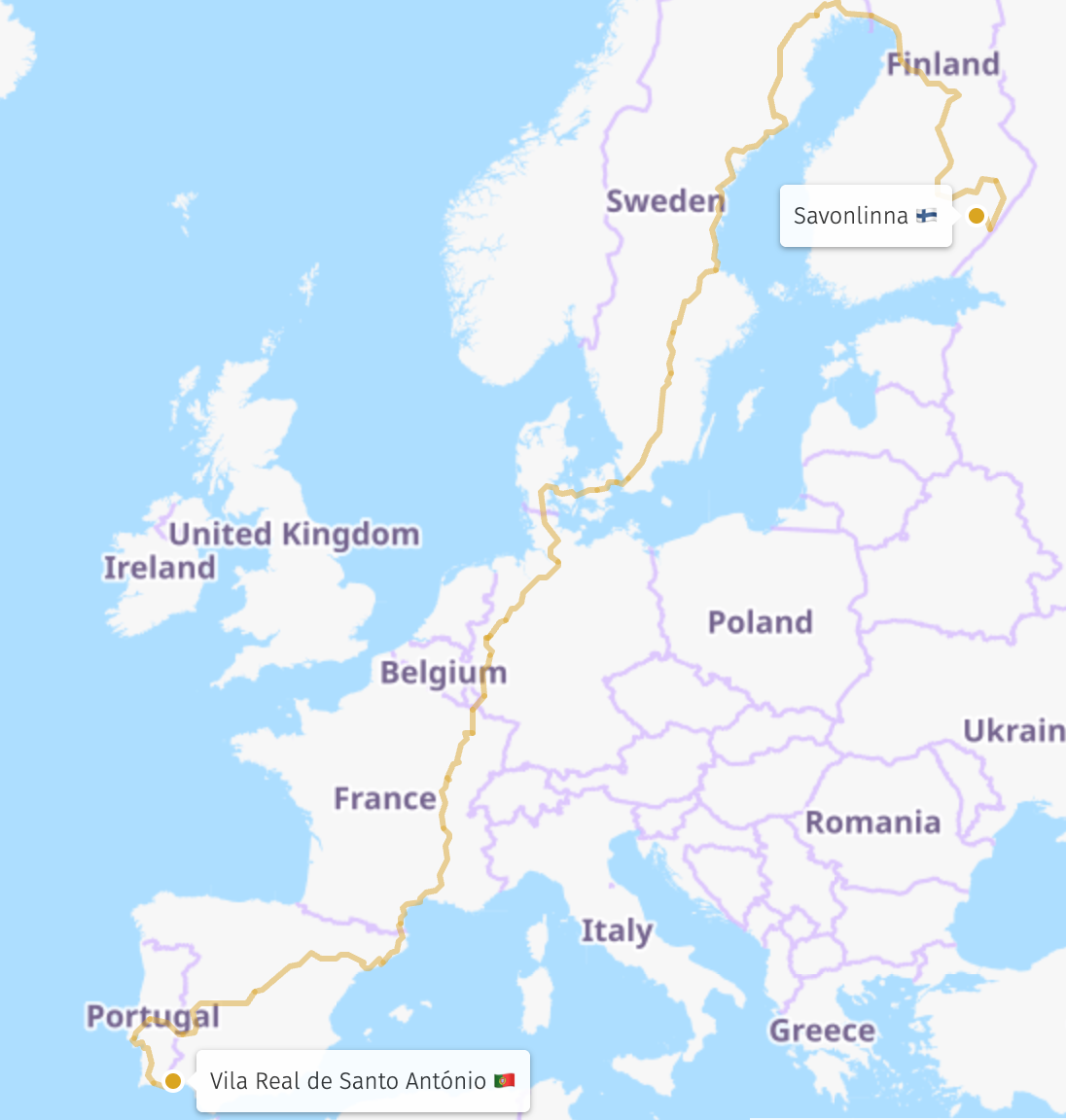
The third option: "But southern Finland to Portugal would have more route-km!"
Yes. And Helsinki to Lagos via Warszawa and Ljubljana would have even more route-km!
But seriously, you can try to calculate what is the greatest route-km between two places in the EU, where no shorter route is available. And that is going to be somewhere in southern Finland, to Portugal. In 2026 it has to route through Haparanda, and through Badajoz, as there is only one way out of Finland and one way into Portugal (Vigo - Porto is closed for works from this summer onwards).
But trying to calculate the total route-km of this is fiendishly hard.
Let's have a go and start by splitting the route into three parts - the Finnish part, the Portuguese part, and the Haparanda to Badajoz part.
The Finnish part is going to need to be the most route-km to Haparanda, and I think this is from Savonlinna (OpenRailwayMap) and routes Savonlinna - Parikkala - Joensuu - Pieksämäki - Kontiomäki - Oulu - Haparanda, 947.9km (routes roughly like this). This is further than the 905.6km from Hanko (OpenRailwayMap) to Haparanda (that routes like this, on the summertime only service avoiding Helsinki), or the 921.1km from Nurmes (that routes like this).
The Portugal part the needs the most route-km from Badajoz, and is Vila Real de Santo António (OpenRailwayMap) in southern Portugal, and you route there Badajoz - Entroncamento - Lisboa Oriente - Vila Real, 639.7km (this is roughly the route). This is longer than to Pocinho in northern Portugal that I had erroneously previously listed.
And that then leaves us with the Haparanda - Badajoz section. Here there are going to be all sorts of routes that are possible, but I started with one important via - Perpignan (as the high speed line and the coastal line via Port Bou are the only ways into Spain without needing to walk, and both route through Perpignan). I used Brouter for this, as it gives the shortest (and not the fastest) rail route, and then corrected the route it gave me, eliminating lines without passenger traffic.
This gave a route: Haparanda - Boden - Gävle - Örebro - Mjölby - Lund C - Kastrup Lufthavn - Ringsted - Hamburg Hbf - Münster Westf - Bottrop Hbf - Oberhausen Hbf - Duisburg Hbf - Köln Hbf - Trier Hbf - Thionville - Nancy - Dijon - Lyon Part Dieu - Perpignan - Barcelona Sants - Madrid Atocha - Badajoz.
I have plotted each of the track sections of this separately on the map here, and all the data is in the Spreadsheet that you can find here. This is 5156.9km.
And this then leaves us with a route-km total of 6744.5km.
But how confident am I about this? That Savonlinna and Vila Real de Santo António are the start and end points of this journey, there I am 95% sure. That 6744.5km is the total route-km, there I really am not sure at all - this is nothing but a best guess.
And this is where this version of the record then becomes so complicated. All that has to happen is for one piece of line to re-open, or for some S-Bahn in the Ruhr to be re-routed, and it throws off the total. There is no real stable route-km total, and given that is what it is about, it strikes me that this one ends up really messy.
How would you actually do this route?
You would have to plan a route very precisely - for each leg there would be only one option, and given some of the trains run very irregularly (especially those between Gävle and Örebro in Sweden that you need to avoid Stockholm and reduce route-km), you could easily be left stranded for hours and hours, waiting for the right train to take.
At present I have not been able to timetable this entirely, getting stuck with issues such as an absence of trains on the line that cuts around the edge of Bremen for example. Eventually I might be able to timetable it.
But for now I can say Savonlinna - Vila Real de Santo António is likely the longest route-km, and the total is around 6744.5km, but I am not entirely sure about that total as I have been unable to timetable the whole lot of it.
Update 6 May, 13:00
Due to numerous repeated questions and misconceptions in responses to the initial blog post on social media, I have re-written this in many places.
Update 25 May, 16:00
A couple of other pieces of information have come to light since I wrote the original post.
First, according to YLE, Oulu - Kemi - Tornio - Haparanda trains will start 10th August at the earliest.
Second, according to this post on Rail Forums there might be fewer trains on the route at the start than we thought.
Third, engineering works means that the timetable for the daily Snälltåget daytime train in the late summer is lengthened, meaning - I think - the timetable I have shown in the table above does not work.
And perhaps most important, if walking from Atocha-Almudena Grandes to Atocha-Cercanías is not allowed, I have identified another way - to route Barcelona Sants - Madrid Atocha-Almudena Grandes - Ciudad Real - Alcazar de San Juan - Madrid Atocha-Cercanías - Badajoz.
But knowing which of these routes is going to be possible, when, is going to take a while longer yet!
Credits
Thanks to Oliver Blanthorn for the list of UIC codes, Nordkommission for the provisional Haparanda timetable, Heikki Piirainen for help understanding Kemijärvi times, and gereon for the original route planning.
Any errors in this work are mine, and mine alone. If you find an error, please tell me and I will happily correct the post!